These are just a few of the possible paths to take in Sicily, whether you want to enjoy a relaxing holiday or simply a horseback ride with your travel companion.
A unique opportunity to take a break from the hectic rhythms of daily life and experience the beauty of Sicilian landscapes is to slow-tourist. Slow tourism involves close interaction with nature in the most remote and least populated areas, such as valleys, hills, woods, grasslands, streams, and waterfalls.
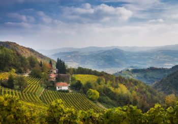
This tour includes sites of cultural importance, outside of the traditional circuits. It also offers a surprising variety of food, wine, and artisan products that have been inherited over the centuries and have made this island an incredible mosaic of influences, traditions, and cultures.
These itineraries, which are based on approximately 11.000 km of trails in Sicily and were chosen by considering certain touristic accessibility. They provide ample facilities, signage, refreshment point, and adequate assistance through highly-experienced guides and horses used in equestrian tourism to offer unforgettable horse riding in complete safety.
These trails are open to all and suitable for outdoor sports enthusiasts. They can be used for mountain biking and trekking with the appropriate equipment.
1. ROUTE OF AIR
Starting point: Castellana Sicula (PA)
– altitude at the a.s.l. – From 950m to 1800m
– route length: about km 22
Travel time: 4 hours (combined speed)
Technical difficulty: Medium
Equipment required: boots/gaiters – cap/helmet
– available boxes: 10
Recommended Period: Between 20 March and 15 Oct
The Madonie Park has a lot of horseriding trails. We recommend this route: you will cross old villages and old drinking troughs and you will enjoy amazing views as you walk along the trail.
The Sanctuary of Madonna dell’Alto is a must-see. It is located at 1600m high and offers a stunning view of the Madonie forests and the valleys below. Monte Quacella is located in Quacella and is the botanical garden of the Madonie Mountains. It is located immediately north of Madonna degli Angeli Valley. This area is famous for its 30 unique world specimens of Abies neurogenesis (firs of the Nebrodi Mountains), an endangered species that dates back to the ice ages.
Piano Cervi is a favorite destination for hikers. This easy trail leads to large green spaces and is surrounded by thick forest vegetation.
You can find more information about the natural areas at the Madonie Park web or contact the Forest Service – Reparto Ippomontato Madonie phone +39 091562437 – mobile. +39 331 5702081
2. ROUTE OF FORESTS
2019 Studio Russo – tutti i diritti riservati
Starting point: Floresta (ME)
Route 1 : Floresta-Lake Cartolari
– altitude at.s.l From 1200 m to 1400m
– route lenght : about 30 km
Travel time: 6 hours (combined speed), 1 hour break
Technical difficulty: Medium to high
Equipment required: boots/gaiters – cap/helmet
Available boxes: Fences, houseposting, or public stables.
Recommended Period: Between 15 April and 20 September
Route 2 : Floresta-Mount Colla
– altitude at a.s.l. From 1200 m to 1500 m
– route lenght : about 15 km
Travel time: 6 hours (combined speed), 1 hour break
– technical difficulty: medio/alte
Equipment required: boots/gaiters – cap/helmet
Available boxes: Fences, houseposting, or public stables.
Recommended Period: Between 15 April and 20 September
Route 3 – Floresta – Favoscuro
– Altitude at the a.s.l.: approximately 1200 m
– route length : about 6,5 km
Travel time is approximately two and a quarter hours (combined pace).
– technical difficulty: medie – percorso a margherita
Equipment required: boots/gaiters – cap/helmet
Available boxes: Fences and Houseposting only
Recommended Period: Between 15 April and 20 September
This village is located in the Nebrodi valley and offers easy walking along a 1100-400 m high path. It is surrounded by large pastures where the largest number of local cattle and goats live. The area is also renowned for its ability to produce soft and fresh cheeses, which can be enjoyed with cold meats.
The area surrounds woods of oaks, beeches and downy oaks . These trees, for their large extension, should be called forests. There, even in summer the sun cannot penetrate.
There are many routes in the area. We recommend that you try them all, up to the natural lakes Tre Arie or Cartolari.
These paths may lead to the possibility of spotting vultures. They are endemic to this region, along with wild cats and black-pigs.
You can find more information on these natural areas at the Parco Dei Nebrodi site or call +39 095 697818
.fusion-accordian #accordion-29547-1 .panel-da8f66bf9f3f016b5 .panel-title a.fusion-accordian #accordion-29547-1 .panel-da8f66bf9f3f016b5 .toggle-content
3. ROUTE OF FIRE
1. Santa Venerina (CT).
2. Starting Point: Nicolosi (CT).
– altitude at.s.l. From 330 m to 2970m
Route length: Every route must not be less than 25km
Travel time: From 6 hours to 7 days
Technical difficulty: Medium-High
Equipment required: gaiters/boots, cap/helmet and high-mountain outfit
Available boxes: 20 per starting point
Recommended Period: Between 20 Aprile and 31 September
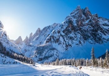
It is one of the most beautiful areas in Sicily because of the rich opportunities it offers Mount Etna. This volcano, which is the second largest in Europe, has been included on the UNESCO World Heritage List.
The incredible and varied touristic offerings of the area satisfy a large number of hikers of different abilities. They will need to deal with a particular territory that is made up of rugged terrain, mostly composed of volcanic formations with their distinctive black color, and wooded areas consisting mostly of beech and birch trees. These have survived the lava flows for millennia.
You can ride on horseback three days to do a complete tour of Etna. The top is at 3000m above sea level. There are other routes that take you to lower altitudes. These routes last between 2 and 5 hours with breathtaking views across the entire Ionian coast.
You can’t forget the incredible faunal and floral diversity found in the area around Etna.
You can find more information on these natural areas at the Parco Dell’Etna website, or call +39 095 821111.
.fusion-accordion #accordion-29547-1 .panel-493dd60c94424b1fb .panel-title a.fusion-accordian #accordion-29547-1 .panel-493dd60c94424b1fb .toggle-content
4. ROUTE OF THE SICANI MOUNTS
Starting point: Prizzi (PA)
Route 1 – Source of River Sosio
– altitude at.s.l From 600 m to 750m
– route lenght : about 7 km
Travel time: 4 hours (combined pace), 1 hour break
Technical difficulty: Medium-low
Equipment required: boots/gaiters – cap/helmet
Available boxes: 6; alternatively, house postings or fences
Recommended Period: Between 20 March and 30 September
Route 2 – Lake Prizzi
– altitude at.s.l From 600 m to 750m
– route length: about 15 km
– Travel time for t: 7 hours (combined pace), 1 hour break
Technical difficulty: Medium-low
Equipment required: boots/gaiters – cap/helmet
Available boxes: 6 fences and housepostings
Recommended Period: Between 20 March and 30 September
Monte Scuro is an area of park that has a lot of naturalistic and historical charm. Here the river sosio rises, and after crossing the Sicanian region for more than 60 km, reaches Mediterranean sea. It flows between the villages Ribera e Sciacca.
This area is home to an old and dense wood that’s rich in oaks, holm and downy oaks. These trees were once used as mule tracks and coal bins in the late 1800s and early 1900s. This excursion, which is very scenic and natural, takes you to a elevation of approximately 700m and reaches an elevation of around 1200 m.a.s.l.
You can climb Monte Indisi on the border of Palazzo Adriano and Prizzi, to enjoy the magnificent panorama offered by the Reserve of Sosio Valley. Also, there is a large portion of the Sicani Mountains. Rocca Busambra (Ficuzza) is a bit further up.
During the warmest months, you can swim in the Sosio river and then explore the underground tunnels that have been dug into the rock for the spring water. On the tracks of an old mule track that was once used by coal men, the walking continues towards Monte Scuro forest. It offers a spectacular view of dense forests and then reaches a large valley with cereal-cultivated soils and pastures.
5. ROUTE OF SAND
Starting point: : Valguarnera Caropepe (EN)
– altitude at.s.l From 600 m to 750m
– route lenght: about km 65
Travel time: 2 days, including breaks, refreshment, and an overnight stay
Technical difficulty: Medium – Low
Equipment required: boots/gaiters – cap/helmet
Available boxes: 3 boxes plus 20 houseposting at start point, 10 boxes to the night break
Recommended Period: Between 20 March and 30 September
This area is dominated by a forest that contains many non-endemic species, such as Eucalyptus. These trees were planted in the 1950s and 60s to support an important paper mill in Piazza Armerina.
The 35-kilometer route traverses the Ronza Park which is home to many bird species , fallow deers and wild boars.
The 90% of the surface is made of sand and leads to the shore of Olivo Dam. It is located in Barrafranca, passes through the archaelogical site of Montagna di Marzo and returns to Piazza Armerina at the end of the afternoon.
You can extend the route to the Villa Romana del Casale nearby, which is an important archaeological site on the UNESCO World Heritage List. Here you can admire the beautiful mosaics, which are still beautifully preserved
6. ROUTE OF WATER
Starting point: Palazzolo Acreide (SR)
– altitude at.s.l Approximately 450m
– route lenght : about km 25
Travel time: 6 hours (combined pace), 1 hour break
Technical difficulty: Medium
Equipment required: boots/gaiters – cap/helmet
– available boxes : 20
Recommended Period: Between 20 March and 15 April
This path combines wellness and fun. It is set in an expansive landscape with rivers that flow through lush Mediterranean scrub. Hidden paths, hills, and valleys offer breathtaking views.
This area lies between the valley and the Manghisi rivers. It is rich in historical evidence that dates back to the Greek-Roman period. You can also visit on horseback some of the important sites that represent the richness and beauty of the Sicilian Baroque Style.
Although the route takes approximately 1 to 2 hours, it can be extended to include a barbeque or other nighttime activities, due to the accommodation facilities that include rooms and stables for horses, the ride may go on for several hours.
Starting point: Castellana Sicula (PA)
– altitude at the a.s.l. – From 950m to 1800m
– route length: about km 22
Travel time: 4 hours (combined speed)
Technical difficulty: Medium
Equipment required: boots/gaiters – cap/helmet
– available boxes : 10
Recommended Period: Between 20 March and 15 Oct
The Madonie Park has a lot of horseriding trails. We recommend this route: you will cross old villages and old drinking troughs and you’ll enjoy amazing views as you walk along the trail.
The Sanctuary of Madonna dell’Alto is a must-see. It is located at 1600m high and offers a stunning view of the Madonie forests and the valleys below. Monte Quacella is located in Quacella and is the botanical gardens of Madonie Mountains. It is located immediately north of Madonna degli Angeli Valley. This area is famous for its 30 unique world specimens of Abies nebrodensis (firs of the Nebrodi Mountains), an endangered species that dates back to the ice ages.
Piano Cervi is a favorite destination for hikers. This easy trail leads to large green spaces and is surrounded by thick forest vegetation.
Starting point: Floresta (ME)
Route 1 : Floresta-Lake Cartolari
– altitude at.s.l From 1200 m to 1400m
– route length: about 30 km
Travel time: 6 hours (combined speed), 1 hour break
Technical difficulty: Medium to high
Equipment required: boots/gaiters – cap/helmet
Available boxes: Fences, houseposting, or public stables.
Recommended Period: Between 15 April and 20 September
Route 2 : Floresta-Mount Colla
– altitude at a.s.l. From 1200 m to 1500 m
– route length : about 15 km
Travel time: 6 hours (combined speed), 1 hour break
– technical difficulty: medio / alte
Equipment required: boots/gaiters – cap/helmet
Available boxes: Fences, houseposting, or public stables.
Recommended Period: Between 15 April and 20 September
Route 3 – Floresta – Favoscuro
– Altitude at the a.s.l.: approximately 1200 m
– route length : about 6,5 km
Travel time is approximately two and a quarter hours (combined pace).
– technical difficulty: medie – percorso a margherita
Equipment required: boots/gaiters – cap/helmet
Available boxes: Fences and Houseposting only
Recommended Period: Between 15 April and 20 September
This village is located in the Nebrodi valley and offers easy walking along a 1100-400 m high path. It is surrounded by large pastures where the largest number of local cattle and goats live. The area is also renowned for its ability to produce soft and fresh cheeses, which can be enjoyed with cold meats.
The area surrounds woods of oaks, beeches and downy oaks . These trees, for their large extension, should be called forests. There, even in summer the sun cannot penetrate.
There are many routes in the area. We recommend that you try them all, up to the natural lakes Tre Arie or Cartolari.
These paths may lead to the possibility of spotting vultures. They are endemic to this region, along with wild cats and black-pigs.
You can find more information on these natural areas at the Parco Dei Nebrodi site or call +39 095 697818
1. Santa Venerina (CT).
2nd Starting Point: Nicolosi (CT).
– altitude at.s.l. From 330 m to 2970m
Route length: Every route must not be less than 25km
Travel time: From 6 hours to 7 days
Technical difficulty: Medium-High
Equipment required: gaiters/boots, cap/helmet and high-mountain outfit
Available boxes: 20 per starting point
Recommended Period: Between 20 Aprilet 30 September
It is one of the most beautiful areas in Sicily because of the rich opportunities it offers Mount Etna. This volcano, which is the second largest in Europe, has been included on the UNESCO World Heritage List.
The incredible and varied touristic offerings of the area satisfy a large number of hikers of different abilities. They will need to deal with a particular territory that is made up of rugged terrain, mostly composed of volcanic formations and sand, and wooded areas, mainly beech and birch trees. These have survived the lava flows for millennia.
You can ride on horseback three days to do a complete tour of Etna. The top is at 3000m above sea level. There are other routes that take you to lower altitudes. These routes last between 2 and 5 hours with breathtaking views across the entire Ionian coast.
You can’t forget the incredible faunal and floral diversity found in the area around Etna.
You can find more information on these natural areas at the Parco Dell’Etna website, or call +39 095 821111.
You can find more information on these natural areas at the Parco Dell’Etna website, or call +39 095 821111.
Route 1 – Source of River Sosio
– altitude at.s.l From 600 m to 750m
– route length: about 7 km
Travel time: 4 hours (combined pace), 1 hour break
Technical difficulty: Medium-low
Equipment required: boots/gaiters – cap/helmet
Available boxes: 6; alternatively, housepostings or fences
Recommended Period: Between 20 March and 30 September
Route 2 – Lake Prizzi
– altitude at.s.l From 600 m to 750m
– route length: about 15 km
– Travel time for t: 7 hours (combined pace), 1 hour break
Technical difficulty: Medium-low
Equipment required: boots/gaiters – cap/helmet
Available boxes: 6 fences and housepostings
Recommended Period: Between 20 March and 30 September
Monte Scuro is an area of park that has a lot of naturalistic and historical charm. Here the river sosio rises, and after crossing the Sicanian region for more than 60 km, reaches Mediterranean sea. It flows between the villages Ribera e Sciacca.
This area is home to an old and dense wood that’s rich in oaks, holm and downy oaks. These trees were once used as mule tracks and coal bins in the late 1800s and early 1900s. This excursion, which is very scenic and natural, takes you to a elevation of approximately 700m and reaches an elevation of around 1200m.
You can climb Monte Indisi on the border of Palazzo Adriano and Prizzi, to enjoy the magnificent panorama offered by the Reserve of Sosio Valley. Also, you will find a large portion of the Sicani Mountains. Rocca Busambra (Ficuzza) is a bit further up.
During the warmest months, you can swim in the Sosio river and then explore the underground tunnels that have been dug into the rock for the spring water. On the tracks of an old mule track that was once used by coal men, the walking continues towards Monte Scuro forest. It offers a spectacular view over dense forests and then reaches a large valley with pastures and soils with cereals.